'Christmas typhoon' heads for Luzon, to hit Metro Manila and nearby areas; Severe tropical storm Nina slows down but intensifies
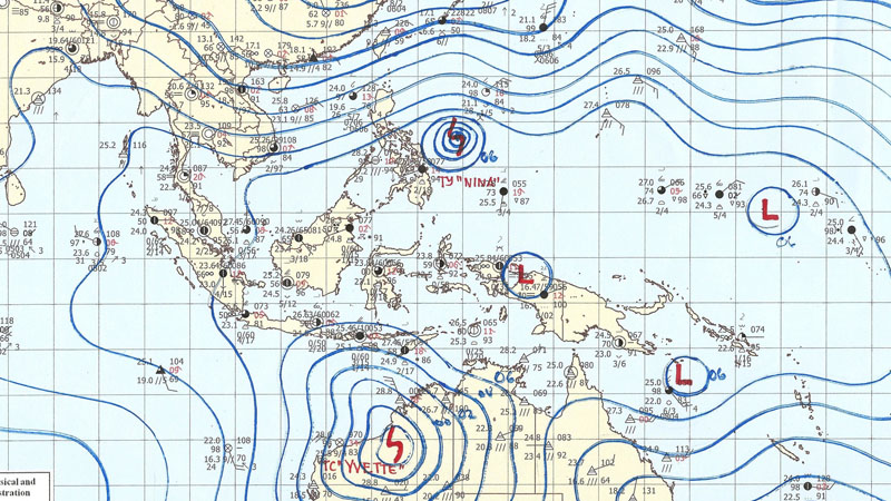
MANILA - Central, Southern and Bicol regions, including Metro Manila, will have stormy weather on Christmas Day and the day after as the three areas lie in the path of typhoon Nina (international codename Nock-Ten).
Severe tropical storm Nina intensified to a typhoon overnight Friday as it was making its way to Luzon, according to the Philippine Atmospheric, Geophysical, Astronomical Services Administration (PAGASA).
In its bulletin as of 5 a.m. Saturday, PAGASA said typhoon Nina is packing winds of 135 kph and gustiness of 165 kph.
From its previous speed of 24 kph in a west-northwest direction, the typhoon slowed down to 17 kph.
Storm Signal No. 1, the first of four storm warnings with Signal Number 4 being the highest, has been raised over the Bicol region and on Northern and Eastern Samar.
Nina is expected to make landfall in the Bicol region at 2 a.m. on Christmas Day and pass over Southern Luzon and Metro Manila.
PAGASA warned of moderate to heavy rain within Nina's 400-km diameter, which could bring floods and landslides while strong winds may topple structures and trees.
The Philippine National Disaster Risk Reduction and Management Council (NDRMMC) and local governments of areas in the path of Nina have been on red alert since Friday night.JTNDJTIxLS0lMjBDb2RlcyUyMGJ5JTIwSFRNTC5hbSUyMC0tJTNFJTBBJTBBJTNDJTIxLS0lMjBDU1MlMjBDb2RlJTIwLS0lM0UlMEElM0NzdHlsZSUyMHR5cGUlM0QlMjJ0ZXh0JTJGY3NzJTIyJTIwc2NvcGVkJTNFJTBBYS5HZW5lcmF0ZWRMaW5rJTNBbGluayUyMCU3QiUwQWZvbnQtc2l6ZSUzQThweCUzQnRleHQtZGVjb3JhdGlvbiUzQW5vbmUlM0Jjb2xvciUzQSUyMzAwMDAzMyUzQmJhY2tncm91bmQtY29sb3IlM0ElMjNmOWY1ZjUlM0IlMEElN0QlMEFhLkdlbmVyYXRlZExpbmslM0F2aXNpdGVkJTIwJTdCJTBBY29sb3IlM0ElMjMwMDAwMzMlM0IlMEElN0QlMEFhLkdlbmVyYXRlZExpbmslM0Fob3ZlciUyMCU3QiUwQWNvbG9yJTNBJTIzRkY2NjMzJTNCJTBBJTdEJTBBYS5HZW5lcmF0ZWRMaW5rJTNBYWN0aXZlJTIwJTdCJTBBY29sb3IlM0ElMjNGRjk5MDAlM0IlMEElN0QlMEElM0MlMkZzdHlsZSUzRSUwQSUwQSUwQSUzQ2ElMjBjbGFzcyUzRCUyMkdlbmVyYXRlZExpbmslMjIlMjBocmVmJTNEJTIyaHR0cCUzQSUyRiUyRnd3dy5leHBhdG1lZGlhLm5ldCUyRmFkdmVydGlzZS13aXRoLXVzJTIyJTIwdGFyZ2V0JTNEJTIyX2JsYW5rJTIyJTIyJTNFQURWRVJUSVNFJTIwSEVSRSUzQyUyRmElM0UlM0NhJTIwaHJlZiUzRCUyMmh0dHAlM0ElMkYlMkZleHBhdG1lZGlhLm5ldCUyRmNsYXNzaWZpZWRzJTJGJTIyJTNFJTBBJTNDaW1nJTIwYm9yZGVyJTNEJTIyMCUyMiUyMGFsdCUzRCUyMkZpbmQlMjBvciUyMHBvc3QlMjBuZXclMjBqb2JzJTJDJTIwbW90b3IlMjBhZHMlMjBhbmQlMjBjbGFzc2lmaWVkcyUyMiUyMHNyYyUzRCUyMmh0dHAlM0ElMkYlMkZleHBhdG1lZGlhLm5ldCUyRndwLWNvbnRlbnQlMkZ1cGxvYWRzJTJGMjAxNiUyRjA1JTJGRmluZC15b3VyLW5leHQtam9iLTIuanBnJTIyJTIwd2lkdGglM0QlMjIxMDAlMjUlMjIlMjBoZWlnaHQlM0QlMjIxMDAlMjUlMjIlM0UlMEElM0MlMkZhJTNFJTBBJTNDYnIlM0UlMEElM0NiciUzRSUwQSUzQyUyMS0tJTIwSFRNTCUyMENvZGUlMjAtLSUzRQ==JTNDc2NyaXB0JTIwc3JjJTNEJTIyJTJGJTJGcGFnZWFkMi5nb29nbGVzeW5kaWNhdGlvbi5jb20lMkZwYWdlYWQlMkZqcyUyRmFkc2J5Z29vZ2xlLmpzJTIyJTIwYXN5bmMlM0QlMjIlMjIlM0UlM0MlMkZzY3JpcHQlM0UlMEElMjAlM0MlMjEtLSUyMGluLWFydGljbGUlMjBhZCUyMC0tJTNFJTBBJTIwJTNDaW5zJTIwY2xhc3MlM0QlMjJhZHNieWdvb2dsZSUyMiUyMHN0eWxlJTNEJTIyZGlzcGxheSUzQSUyMGJsb2NrJTNCJTIyJTIwZGF0YS1hZC1jbGllbnQlM0QlMjJjYS1wdWItNTAwNjI0MTU4MzU4MTg0OSUyMiUyMGRhdGEtYWQtc2xvdCUzRCUyMjg1MjYwOTM2MTElMjIlMjBkYXRhLWFkLWZvcm1hdCUzRCUyMmF1dG8lMjIlM0UlM0MlMkZpbnMlM0UlMEElM0NzY3JpcHQlM0UlMkYlMkYlMjAlM0MlMjElNUJDREFUQSU1QiUwQSUyOGFkc2J5Z29vZ2xlJTIwJTNEJTIwd2luZG93LmFkc2J5Z29vZ2xlJTIwJTdDJTdDJTIwJTVCJTVEJTI5LnB1c2glMjglN0IlN0QlMjklM0IlMEElMkYlMkYlMjAlNUQlNUQlM0UlM0MlMkZzY3JpcHQlM0UlMEE=
We use cookies to enhance your browsing experience, serve personalized content, and
analyze our traffic. By clicking "Accept All", you consent to our use of cookies.
Cookie Settings
Always Active
These cookies are essential for the website to function properly. They cannot be disabled.
Optional
These cookies help us understand how visitors interact with our website by collecting and
reporting information anonymously.
Optional
These cookies enable enhanced functionality and personalization, such as remembering your
preferences.
Optional
These cookies are used to track visitors across websites to display relevant and engaging
advertisements.













Comments
Leave a Comment